v4.6.0
New: Translations
New: Barometer / QNH settings improved
New: traffic view improved
v4.5.1
New: Support for Bluetooth LE devices (e.g. STRATUX)
New: Lower zoom levels
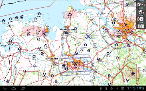
New: Detailed maps
Fix: User Waypoint List misses first category
Fix: Fix Stratux NMEA traffic message missing ID
v4.5.1
New: Support for Bluetooth LE devices (e.g. STRATUX)
New: Lower zoom levels
New: Detailed maps
Fix: User Waypoint List misses first category
Fix: Fix Stratux NMEA traffic message missing ID
v4.4.1
New: Location Debug Option
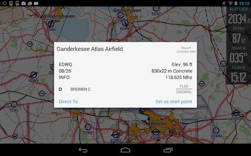
New: DFS AIP links in airport screen added
New: chart sheet option to remove a chart from map
New: SR and SS times added
Fix: Airspace list misses some airspaces
Fix: widget cannot be set to "END"
Fix: black screen while loading DFS charts
v4.1.2
New: Notam translations
New: Notam share options
New: vertical airspace view improved
Fix: move maps to sd-card
Fix: user waypoint not updated in route after change
Fix: translations
Fix: flight form does not accept date before year 2000
Fix: some ui bugs
Updated api level
Fix: wrong color for TRA airspace
v4.0.3
Fix: double traffic
Fix: Language
New: Ui Dark mode
New: significant user interface optimizations
New: Help text
New: Flight export as text (share)
New: Tablet ui mode
New: NOTAM translations
Fix: Notam display
Fix: excel import/export
v3.41.0
notam display improved
map improved
better support for font size changes
improved excel in/export
Fix: several bug fixes and performance improvements
v3.41.0
notam display improved
map improved
better support for font size changes
improved excel in/export
Fix: several bug fixes and performance improvements
v3.40.0
Fix: Double click on a notam does not expand notam text
New: search for saved routes
Fix: restore location after start
v3.37.4
New: Simplified/Automatic connection to location and traffic sources
New: option to show traffic id on map
Fix: Mode S altitude reference
Fix: X-Plane 11/12 support
Fix: TMA airspace display
v3.40.0
Fix: Double click on a notam does not expand notam text
v3.39.0
New: search for saved routes
v3.38.0
Fix: restore location after start
v3.37.4
New: Simplified/Automatic connection to location and traffic sources
New: option to show traffic id on map
Fix: Mode S altitude reference
Fix: X-Plane 11/12 support
Fix: TMA airspace display
v3.39.0
New: search for saved routes
v3.38.0
Fix: restore location after start
v3.37.4
New: Simplified/Automatic connection to location and traffic sources
New: option to show traffic id on map
Fix: Mode S altitude reference
Fix: X-Plane 11/12 support
Fix: TMA airspace display
v3.38.0
Fix: restore location after start
v3.37.4
New: Simplified/Automatic connection to location and traffic sources
New: option to show traffic id on map
Fix: Mode S altitude reference
Fix: X-Plane 11/12 support
Fix: TMA airspace display
v3.36.0
internal release
v3.35.0
fix: altitude correction
traffic fixes
some code improvements
v3.32.2
Fix: charts only appear after a restart on some devices
interface improvements
v3.31.0
Fix: show track on map options
improved theming
code improvements
v3.37.0
New: Simplified/Automatic connection to location and traffic sources
New: option to show traffic id on map
v3.36.0
internal release
v3.35.0
fix: altitude correction
traffic fixes
some code improvements
v3.32.2
Fix: charts only appear after a restart on some devices
interface improvements
v3.31.0
Fix: show track on map options
improved theming
code improvements
v3.33.0
traffic fixes
some code improvements
v3.32.2
Fix: charts only appear after a restart on some devices
interface improvements
v3.31.0
Fix: show track on map options
improved theming
code improvements
v3.30.0
New: show track statistics and map
improved user guidance
map download improved
v3.29.2
New: Show closed airports on map
Fix: X-Plane 12 support
Fix: Excel import/export compatibility
Some code improvements
v3.31.0
Fix: show track on map options
improved theming
code improvements
v3.30.0
New: show track statistics and map
improved user guidance
map download improved
v3.29.2
New: Show closed airports on map
Fix: X-Plane 12 support
Fix: Excel import/export compatibility
Some code improvements
v3.28.3
Fix: route reorder does not change route on map
Improved database performance
v3.28.3
Fix: route reorder does not change route on map
Improved database performance
v3.27.2
Fix: ScaleBar display
New: Better next WP selection algorithm
Fix: Excel flightTime/blockTime export
Fix: FPL WP export
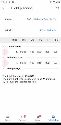
New: calc parameter aircraft selection
Fix: TMA null/null removed
v3.27.2
Fix: ScaleBar display
New: Better next WP selection algorithm
Fix: Excel flightTime/blockTime export
Fix: FPL WP export
New: calc parameter aircraft selection
Fix: TMA null/null removed
v3.26.2
Fix: Excel export
Fix: No traffic received via bluetooth connection
Fix: vertical airspace profile lower limit agl values
Fix: Tracks have wrong first points
Fix: traffic not visible with invalid nmea messages
New: added flight time formula in excel-export
v3.26.2
Fix: Excel export
Fix: No traffic received via bluetooth connection
Fix: vertical airspace profile lower limit agl values
Fix: Tracks have wrong first points
Fix: traffic not visible with invalid nmea messages
New: added flight time formula in excel-export
v3.25
New: Improved Map Style
Fix: IGC Export crashing
Fix: map update notification
v3.24
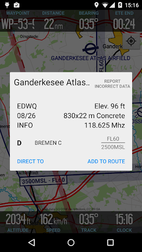
New: Obstacles on map
New: Reporting points for new regions added
New: Show Notam-ID on map
Improved map layout
v3.25
New: Improved Map Style
Fix: IGC Export crashing
Fix: map update notification
v3.24
New: Obstacles on map
New: Reporting points for new regions added
New: Show Notam-ID on map
Improved map layout
v3.23.1
New: user waypoint import improved
New: position share option
New. My position dialog
New: IGC flight track export
v3.21.2
Fix: AGL altitude
New: extended stratux information displayed on gps page
Fix: Bluetooth gps source gets no valid position
metar/taf time format improved
v3.20.4
New: Notam list improved
Fix: Bluetooth gps source gets no position update
Fix: User waypoint form keyboard disappears immediately
Fix: flight route calculation params
user waypoint screen improved
Improved form theme
ATZ airspace added to airspace warning system
X-Plane support improved
v3.21.0
New: extended stratux information displayed on gps page
Fix: AGL altitude values not correct
Fix: Bluetooth gps source gets no valid position
metar/taf time format improved
v3.20.4
New: Notam list improved
Fix: Bluetooth gps source gets no position update
Fix: User waypoint form keyboard disappears immediately
Fix: flight route calculation params
user waypoint screen improved
Improved form theme
ATZ airspace added to airspace warning system
X-Plane support improved
v3.19.0
New: X-Plane 11 support
Fix: Speed/Track widgets not updated
v3.18.2
Fix: Traffic view not shown on tablets in landscape orientaion
Fix: Hillshading options not restored after app restart
New: time to contact added to airspace profile
various improvements
v3.17.2
Fix: Import of MOBAC generated map files
Fix: map download improved
Reduced default takeoff speed (20kt)
New: vertical airspace profile default activated
Fix: double tap on map
v3.17.2
Fix: Import of MOBAC generated map files
Fix: map download improved
Reduced default takeoff speed (20kt)
New: vertical airspace profile default activated
Fix: double tap on map
v3.16.3
Fix: map style for italy
Fix: external map storage does not work
New: Performance improvements
Fix: reduced memory consumption during map download
Fix: vertical airspace profile RMZ display
New: support for non-mandatory reporting points
Fix: Map offset at track-up mode
Bugfixes
v3.16.3
Fix: map style for italy
Fix: external map storage does not work
New: Performance improvements
Fix: reduced memory consumption during map download
Fix: vertical airspace profile RMZ display
New: support for non-mandatory reporting points
Fix: Map offset at track-up mode
Bugfixes
v3.16.0
New: add gestures to vertical airspace profile
New: wind speed unit m/s added
New: Hide zoom buttons settings
New: decreased hide airspace alt step
New: online search improved
New: Allow 5 route widgets
New: Add support for non mandatory rep points
Fix: vertical airspace profile: distance label layout break
Fix: Special chars on map
Fix: hide airspaces
Fix: missing country boundaries in map
Fix: label line wrap on smaller displays
updated dependencies
v3.13.3
New: Improved altitude correction
New: support for hillshading
New: baro altitude support
Fix: some bugs
v3.11.2
New: Setting to disable metar-taf decoding
New: ETE displays remaining time in seconds (90s)
New: Info sheet by map double tap
New: Show location in chart screen
v3.10.2
Improved support for
* SkyEcho 2 (GDL90)
* Garrecht AT-1 (FLARM-NMEA/GDL90)
* Stratux (GLD90)
v3.10.2
Improved chart management
Tablet layout fixes
v3.10.2
Improved support for
* SkyEcho 2 (GDL90)
* Garrecht AT-1 (FLARM-NMEA/GDL90)
* Stratux (GLD90)
v3.9.2
New: Full SkyEcho 2 compatibility
New: Settings for hide airspaces
v3.8.1
New: NMEA/FLARM via UDP
Fix: SkyEcho traffic no altitude
Fix: tcp connection after wifi lost
Fix: faster map updates
v3.10.2
Improved support for
* SkyEcho 2 (GDL90)
* Garrecht AT-1 (FLARM-NMEA/GDL90)
* Stratux (GLD90)
v3.9.2
New: Full SkyEcho 2 compatibility
New: Settings for hide airspaces
v3.8.1
New: NMEA/FLARM via UDP
Fix: SkyEcho traffic no altitude
Fix: tcp connection after wifi lost
Fix: faster map updates
v3.7.1
Fix: Route loading dialog
Fix: airspace GND label on map
Increased chart border width
Increased compatibility for custom openAir 'Platzrunden' file
v3.10.0
Improved support for
* SkyEcho 2 (GDL90)
* Garrecht AT-1 (FLARM-NMEA/GDL90)
* Stratux (GLD90)
v3.9.2
New: Full SkyEcho 2 compatibility
New: Settings for hide airspaces
v3.8.1
New: NMEA/FLARM via UDP
Fix: SkyEcho traffic no altitude
Fix: tcp connection after wifi lost
Fix: faster map updates
v3.7.1
Fix: Route loading dialog
Fix: airspace GND label on map
Increased chart border width
Increased compatibility for custom openAir 'Platzrunden' file
v3.6.3
Fix: SwiftKey form input
Fix: Route import dialog scrolling
v3.7.1
Fix: Route loading dialog
Fix: airspace GND label on map
Increased chart border width
Increased compatibility for custom openAir 'Platzrunden' file
v3.6.3
Fix: SwiftKey form input
Fix: Route import dialog scrolling
v3.6.1
New: glider symbol
Traffic relative altitude textsize improved
Neu: Support for route planning via charts.aero
v3.5.6
New: FS2020 support
Fix: Metar/Taf view missing visibility value
Fix: landscape layout
v3.6.3
Fix: SwiftKey form input
Fix: Route import dialog scrolling
v3.6.1
New: glider symbol
Traffic relative altitude textsize improved
Neu: Support for route planning via charts.aero
v3.5.6
New: FS2020 support
Fix: Metar/Taf view missing visibility value
Fix: landscape layout
v3.5.2
Fix: inport/export of waypoints
time input fields improved
Fix: wrong name in waypoint widget
Fix: aircraft input form improved
v3.2.1
- Fix: GPS settings
v3.2
- Fix: Chart visibility after map reset
- Fix: Missing entries in airspace list
- Improved Metar/Taf decoding
- New: gps data overwrite option
Some bugfixes
Some bugfixes
Some bugfixes
Some bugfixes
Some bugfixes
Some bugfixes
Some bugfixes
Some bugfixes
Some bugfixes
Some bugfixes
Some bugfixes
Some bugfixes
Some bugfixes
Some bugfixes